RTAB mapping
" RTAB mapping is a RGB-d , Stereo and Lidar graph based SLAM approach "
Here 'd' in RGB-D means depth!
- RT - real-time
- AB - Appearance Based
RTAB mapping Definition
RTAB mapping is a real-time appearance-based mapping technique, As its name suggests it is using the visual appearance of an environment to create a map . so the data collected from visual sensors are used to localize and map the environment. The loop closure algorithm running inside RTAB mapping is used to understand whether the robot has seen a location before . the map is expanded /generated as the robot moves to a new place. the system will continuously capture images and use it for loop closure. As the number of images increases the complexity of this system will increase as it has to loop through all images to understand the feature matching so that it can implement loop closure
loop closures:
" In simple words it is the process of finding matches between the current and previously visited locations in SLAM , there is 2 type of loop closure implementation available - local and global! "
The local loop closures are more likely to be affected by noise values as it is more dependent on estimated robot position, RTAB map uses global loop for better performance ,In the global loop closures approach, a new location is compared with previously viewed locations. If no match is found, the new location is added to the memory. As the robot moves around and the map grows, the amount of time to check the new locations with ones previously seen increases linearly.
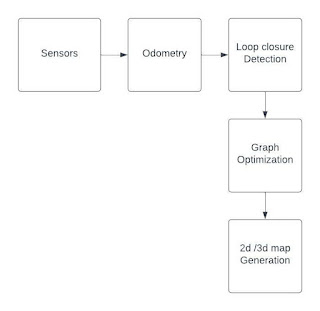
The first stage of RTAB mapping is to take data from the vision-based sensors
and position data from odometer-related sensors, the
odometry sensors can be IMU, Lidar, Visual odometry, or
wheel encoder.
based on this 2 kind of data it will implement loop
closure algorithm .
and in the next stage it will be having Graph
optimization followed by map generation.


